
June 21, 2012
Today we spent the whole day in the lab, I would prefer to spend at least half of the day outside collecting data since we are in Kauai. Hopefully we will spend more time ground truthing and collecting data.
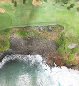
In the lab we made our data dictionary, which will help us during our ground surveys of plants. This will help us in the long run during our analysis. We analyzed the imagery that we acquired from the kite and the fixed wing airplane the last two days. Our goal is to mosaic the imagery to create a orthrophoto and a DEM. I created a 3d image of the Heiau area with vegetation surrounding it from images collected from a kite. The next step will be to create a DEM of this and compare it to LIDAR DEM data.
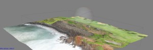
3D model
This was created from 200 photos
My next step will be to georeference the image using the markers we placed yesterday.
Hopefully tomorrow we will be able to get outside and collected more data.
Ryan