
Hoouluia, Mahaulepu
June 20, 2012Good evening,
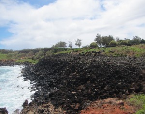
Data acquisition has commenced and research projects are taking shape. The plant research team began the day recording spectral signatures for various plant species from the vegetation grid at Makauwahi Cave Reserve. Our archaeological team joined the hydrology group for a tour of the sinkhole. Dr. Burney lectured on the natural processes contributing to cave formation in the region. Following exploration of Makauwahi cave, our entire group walked along the coast to Hoouluia Heiau. Hoouluia, a general term for a fishing heiau and the name currently identified with this archaeological structure, is a large heiau located on the Mahaulepu Trail approximately 2km from Makauwahi. Tomorrow we will begin image documentation for this structure by employing pole aerial photography, kite aerial photography, and the single-wing airborne platform described in yesterday’s post. I plan to compare image resolution among these data acquisition techniques to assess the best method for creating an image collection for basalt archaeological features. Due to the unique nature of construction materials and techniques, I believe that fine-grained spatial imaging will improve the documentation of features that do not photograph well under normal circumstances. Below is a photograph of Hoouluia.
– John Thornton O’Connor