
Acridge: Mapping Surface Water Flow as a Predictor of Submarine Groundwater Discharge
Contents
[ hide ]
Mapping Surface Water Flow as a Predictor of Submarine Groundwater Discharge
Kelly Acridge Department of Geography, CSU Sacramento, Sacramento, California, 95819Introduction
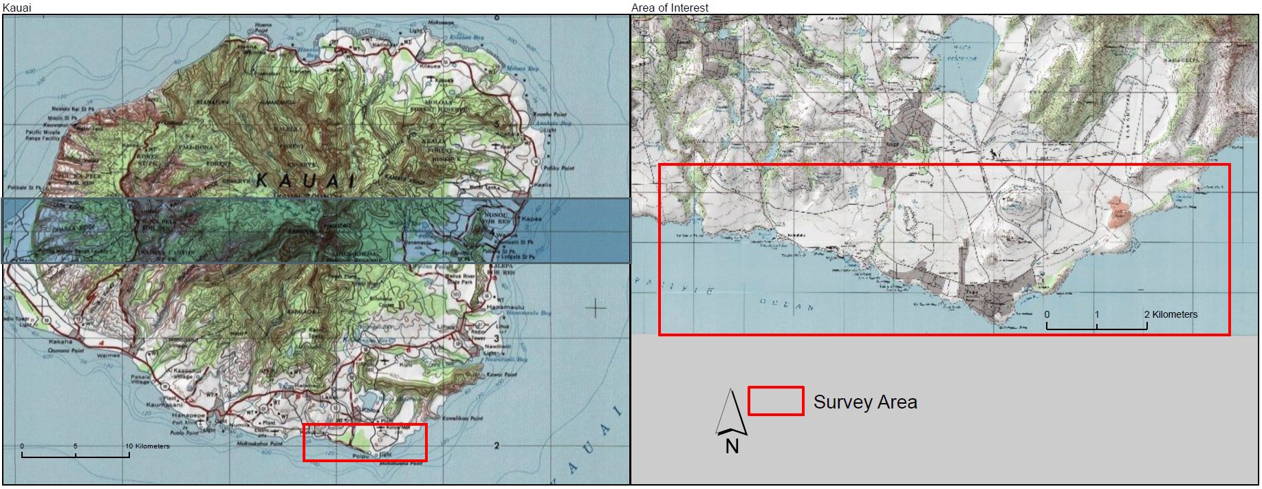
Submarine Groundwater Discharge (SGD) is the portion of groundwater flowing outward from coastal areas that occurs below the sea surface. While participating in a National Science Foundation funded Research Experience for Undergraduates program that conducted an initial survey of SGD in the Southwest area of Kauai, HI, I hypothesized that SGD is related to surface drainage.
Materials and Methods
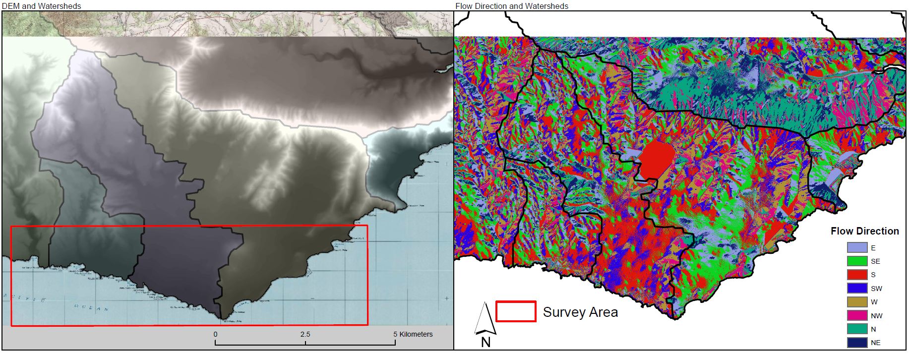
The analysis was performed using ArcMap 10.0 GIS software, including Spatial Analyst extension. The initial data was a 10m Digital Elevation Model (DEM) of the island of Kauai. The DEM was used to calculate surface water flow direction and accumulation areas.
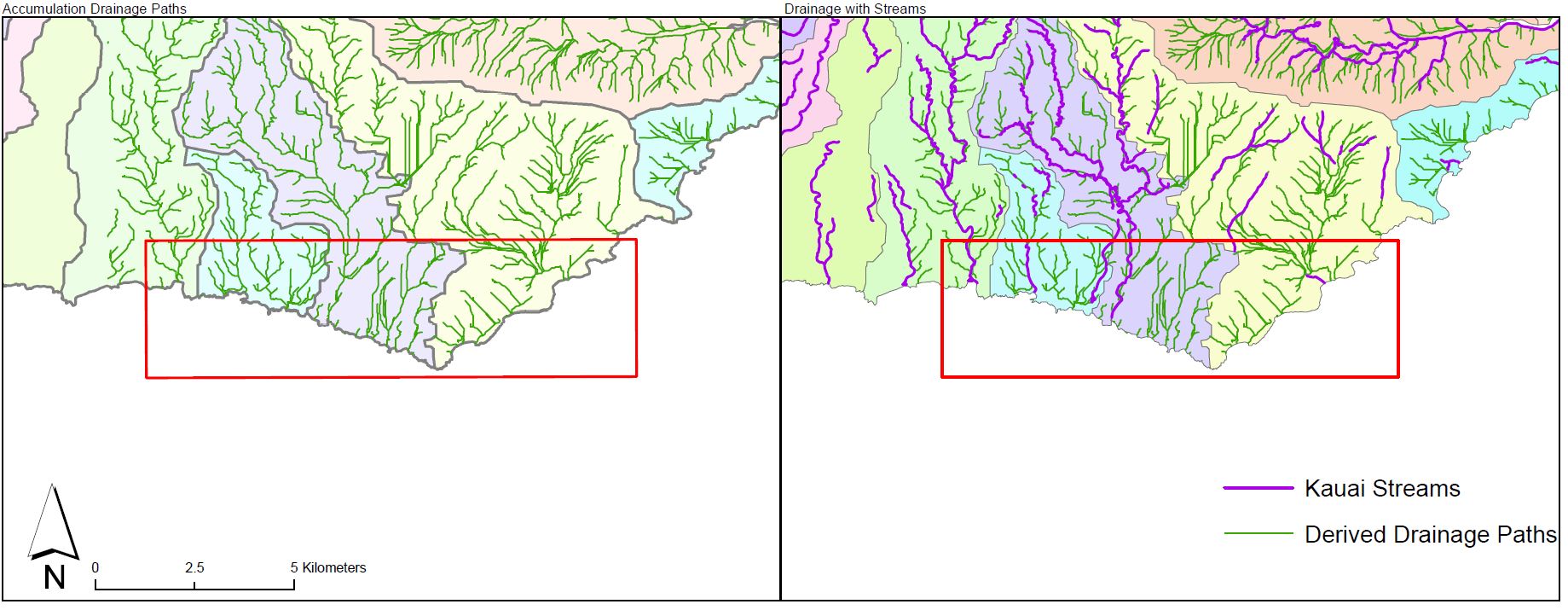
Once surface water accumulations were modeled from the DEM, the results were compared to existing streams on Kauai (non-perennial and perennial). This allowed for quick identification of areas here the DEM indicates groundwater would be flowing but no current stream exists.
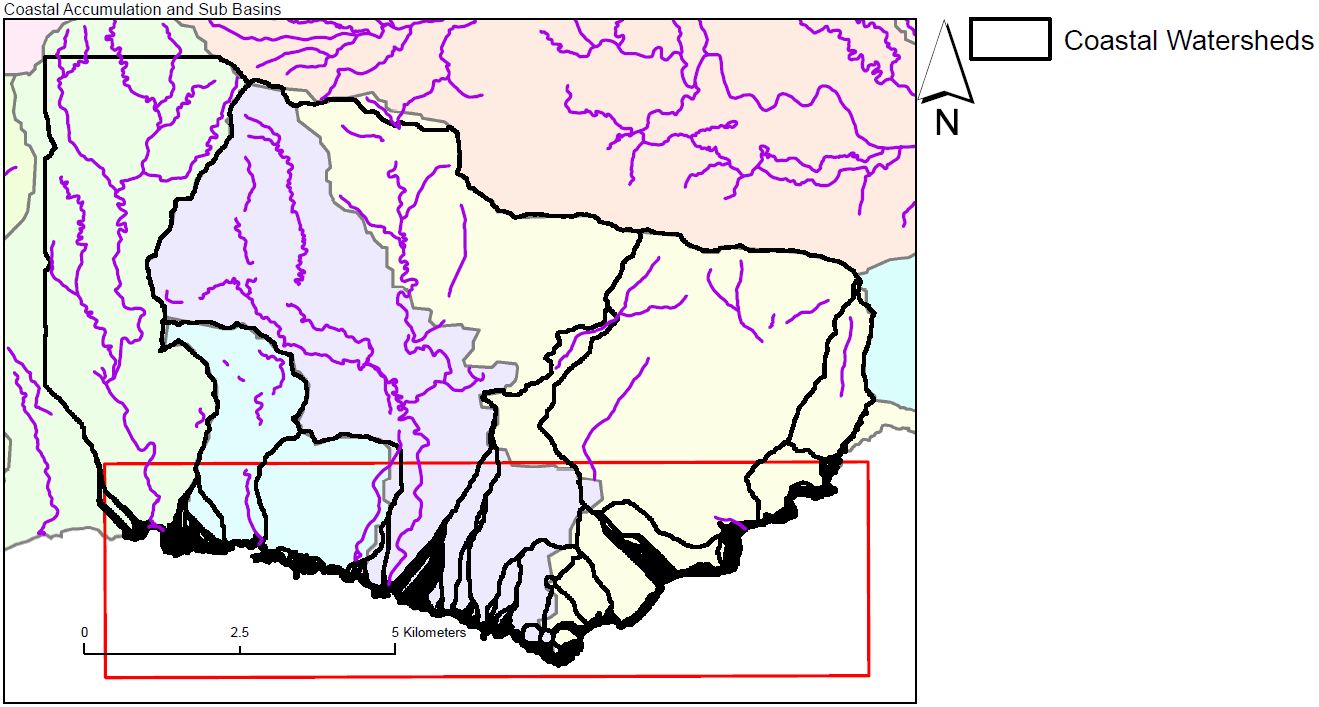
Next, flow accumulation was calculated for the entire coastline within the survey area, and sub-basins were generated for each area with flow accumulation greater than zero.
Results
The initial result of this project was the creation of a map showing the calculated accumulation of drainage basins as they flow from the land into the ocean, as if observed from an offshore observer, for every 1 kilometer of distance.
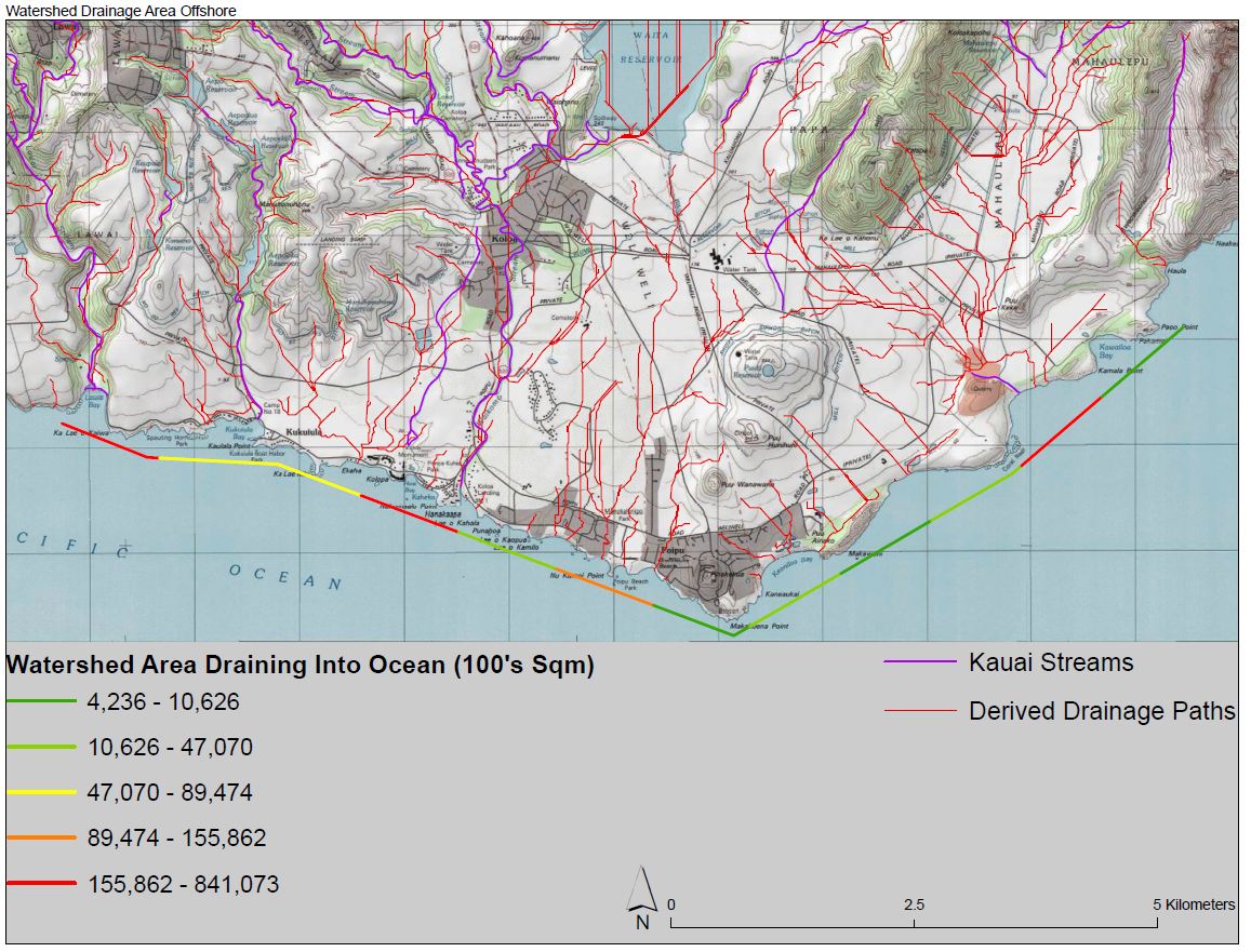
Of particular note is the area just offshore near Poipu beach (colored orange in the graphic), it is the only area of high-calculated offshore drainage that does not have an existing surface water feature. This could indicate an excellent area to investigate for SGD since the effects of nearby streams will be minimized while the potential for groundwater flow is predicted high.
Next, I calculated the volume of freshwater draining into the offshore area. For this model, I made a simple assumption that the input of water from rainfall would equal the discharge of freshwater into the ocean. This was done to expedite the initial analysis in order to evaluate if a more rigorous analysis would be fruitful.
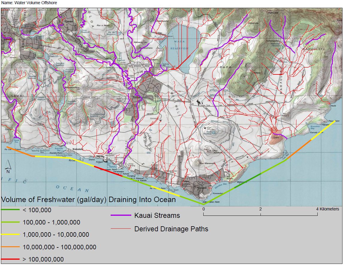
Interestingly, the area surrounding Poipu beach still has greater calculated discharge than any other region that does not have a nearby stream or river.
Conclusion and Discussion
This project shows the ability of GIS software to run complicated analyses from limited initial data. The area around Poipu beach was identified as a strong candidate for further research using ground surveying equipment and other measuring tools. Another member of the hydrology team analyzed the temperature and salinity logs collected during the two o weeks on Kauai, but as of the creation of this poster had not finished their analysis. Ideally, this data will be merged with the predicted water volume map to check for any correlation between observed and predicted SGD.
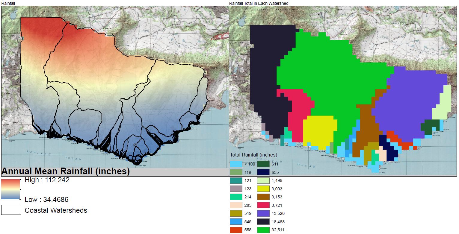
Some errors were noted during the analysis that could not be properly accounted for. One such error came from the systemic error introduced when converting raster data into a non-grid format (calculating rainfall totals within a watershed from a rainfall raster and a watershed polygon). The raster cell values are not truncated if part of the cell is transected by the polygon or line. Additionally, there is a level of error introduced when interpolating point data into a raster, or when using a raster to represent any data that does not perfectly fit into a grid, such as the rainfall raster obtained from the Hawai’i state GIS website. These errors contributed to the mean annual rainfall for the survey area being calculated at ~260 million gal/day while the official mean annual rainfall as reported by the Kauai water budget document (Shade) is ~160 million gal/day. Since the purpose of this project was to test the feasibility of this method rather than obtain concrete flow volumes this was deemed acceptable.
Acknowledgments
This project was made possible through funding by the National Science Foundation Research Experience for Undergraduates program. Reward #1005258 Geospatial Research and Mapping (GRAM). I would like to thank Suzanne Wechsler, Carl Lipo, Chris Lee, David Burney, Lida Burney, Matt Becker, Wes Elles, Alison Yoho, Alesssandra Pistoia, Courtney Fiamengo, Jake Kovalchik, Mike Ferris, Paul Nesbit, Briton Voorhees, The National Tropical Botanical Garden on Kauai, HI, and the group that maintains the Makauwahi cave preserve.
Literature Cited and Data Sources
DEM: USGS national elevation dataset, retrieved from the web on 7/1/12 (http://nationalmap.gov/viewer.html)
Hawai’i Hydrology files (stream features, reservoirs, rainfall, coastline, aquifer, watersheds): retrieved from the web on 7/1/12 (http://hawaii.gov/dbedt/gis/download.htm)
Moore, Willard S. “The Effect of Submarine Groundwater Discharge on the Ocean.” Annual Review of Marine Science 2.1 (2010): 59 -88. Print.
Shade, Patricia J. “Water Budget f or the Island of Kauai, Hawaii” U.S. GEOLOGICAL SURVEY Water-Resources Investigations Report 95 -4128 (1995): Print
Map Production date: 7/6/12